


Graig Fawr
WNW-NNW (290*-330*)
Club Pilot + 50h
Open site
Site sheet
General information
Height
820
ft
Site Fee
£
0
250
m
7.025
Notam Code
West Glamorgan Commoners do not approve of flying - do not upset them
Landowner
Duke of Beaufort (West Glamorgan Commoners have grazing rights)
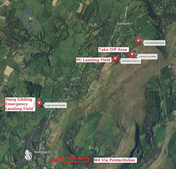
Lots of room to take off - beware turbulence from lower obstructions. Expansive top landing area. Emergency HG bottom landing field in bow of river directly in front (bugs.hypnotist.navigate) - track down over railway but no vehicle access
Remember to NOTAM/CANP if flying weekdays (check flying midweek paragraph for instruction guide)
SWWSC Site Record
Nick Roberts 2003 93.9km
Site information
Essentially thermalling site for XC - not soaring due to shallow slope and turbulence from lower trees
EXTREMELY sensitive site.
DO NOT: Fly close to livestock.
Fly if lambs on hill.
Block track.
Drive onto moor (north or south)
Rules
No official bottom landing area. Track very muddy after wet weather - vehicles get stuck. Vehicle vandalism reported
Hazards
Directions
From M4 junction 48 head for Pontardulais. Take road to Garnswllt, turn right up hill. After crossing cattle grid take track off right. Within 200m track splits, bear left continue 100m. Park in open area to right
What3Words
marinated.essay.averts
crowbar.gong.beefed
fruits.gates.scrubbing
Parking point
Take off point
Landing point
bugs.hypnotist.navigate
Emergency landing point