Search Results
31 results found with an empty search
- Rhossili | SWWSC
< Back Rhossili WSW-WNW (250*-290*) / NW-N (315*-360*) cliffs experienced pilots only Club Pilot + 50h, Club Pilot Members only Site sheet General information Height 600 ft Site Fee £ 0 183 m 7.013 Notam Code Club pays annual fee to Trust. This is member only site as requested by National Trust Landowner National Trust Two dedicated take off areas - pimple and top of hill. Bottom landing only on sandy beach but aware of public - first 1/3 busiest. Rhossili is a premier coastal soaring site in an area of Outstanding Natural Beauty and is of national importance. We are privileged to fly here. There is limited XC potential. Alternative things to see and do if it is not flyable. Rhossili is owned by the National Trust and is a very sensitive site. In the past, due to incidents and site rule infringements, this site has come very close to being lost to free flying. We ask that all club members take an active role in ensuring the site is safeguarded and our permit to fly there is not compromised. Wardens are always present and rule infringements do not go unnoticed. You would make yourself extremely unpopular in the paragliding community if you are unable to follow a few simple easy to follow rules and your behaviour leads to the loss of this stunning site Parakite flying has become very popular at Rhossili and is likely to become even more so in the future. All pilots are advised that parakites often fly much faster than conventional paragliders, including on landing approaches and they may appear suddenly. All pilots of all types of wings (and any accompanying spectators) need to be more aware of landing approaches and observant of their surroundings when moving around, particularly at the Pimple (lower take off site). Checking the air space before you stand up, move around the take off/landing areas and particularly before you launch is essential to reduce the risk of a collision. Do NOT use raised beach or cliffs for launching/landing - FORBIDDEN SWWSC Site Record Nick Roberts 2012 11.5km https://www.xcleague.com/xc/flights/2012737.html?vx=27200424 Site information Premier coastal soaring site in Area of Outstanding Natural Beauty, national importance. Privileged to fly here. Limited XC potential. Very sensitive - incidents and rule infringements nearly lost site in past. Wardens always present, infringements noticed VERY sensitive site . Park only in designated car parks - keep access clear for emergency vehicles. Do not take off if tide coming in with little beach left. No taking off when/if orographic cloud forming. Take-offs/landings only in designated areas. No launching/landing on cliffs. Under NO circumstances use raised beach for launching/landing - it is SSSI. No shortcuts over raised beach. Use official footpaths from beach. Pilots may be asked for BHPA and SWWSC membership proof Rules During morning/evening high tides water comes in quickly. Orographic cloud can form rapidly Rhossili cliffs Only experienced pilots should soar cliffs . Flying close to the NNW facing cliffs at Rhossili is a high risk activity. All pilots should exercise great caution when flying the cliffs, as a collapse there may result in contact with the terrain, which is mostly steep or vertical. The cliffs are far less forgiving than the main ridge, which is largely gently sloping. Pilots must not get blown back when flying cliffs - severe turbulence in lee. Hazards Directions From M4 J42 take A483 into Swansea then A4067 along seafront towards Mumbles. 2km before Mumbles turn right onto B4436 for South Gower. Turn right at Pennard Church, after 1km turn left onto A4118. Follow to Scurlage then turn right for Rhossili on B4247 What3Words itself.channel.commended nips.submits.applause Top launch, pimple, and beach only - everywhere else OUT OF BOUNDS Parking point Take off point Landing point N/A Emergency landing point Previous Next
- Site Guides (List) | SWWSC
SWWSC Site Guides List Search a flying site Open site Club Pilot + 50h, +50h, Club Pilot Read More Abernant (Bryn Mawr) E (090*) Members only Club Pilot Read More Bryncaws (Mynydd Marchywel) E-SE (090*-135*) Members only Club Pilot + 50h Read More Cwmafan (Foel Fynyddau) SE-SSW (135*-200*) Open site Pilot Read More Cwmparc (Graig Fach) NNE-ENE (020*-060*) Members only Club Pilot Read More Fan Gyhirych SW-W-NW-NE (220*-050*) Open site Club Pilot +10h Read More Fan Hir NNE-E (023*-070*) Members only Club Pilot Read More Ferryside SW-WNW (220*-290*) Open site Club Pilot + 50h Read More Graig Fawr WNW-NNW (290*-330*) Open site Club Pilot Read More Heol Senni (Fan Bwlch Chwyth) NNE-ENE (023*-070*) Members only Club Pilot Read More Lletty Siac (Mynydd Marchywel) W-WNW (250*-290*) Members only Club Pilot Read More Marros Down SSW-SSE (165*-195*) Open site Club Pilot Read More Moel Feity (Training Site) E (090*) Open site Club Pilot Read More Newgale WSW-WNW (260*-280*) Open site Club Pilot Read More Rhiw Wen (Tair Carn Uchaf) NNW-NNE (335*-025*) Members only Club Pilot + 50h, Club Pilot Read More Rhossili WSW-WNW (250*-290*) / NW-N (315*-360*) cliffs experienced pilots only Members only Club Pilot Read More Seven Sisters (Hirfynydd) NW-N (310*-360*) Open site Pilot Read More Southerndown SW (200*-230*)
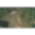
- Moel Feity (Training Site) | SWWSC
< Back Moel Feity (Training Site) E (090*) Club Pilot Open site Site sheet General information Height 1500 ft Site Fee £ 0 457 m Notam Code No formal arrangement but farmer seems happy Landowner Farmer seems happy - be polite if approached Walk up hill, take off where hill starts to level out. When bottom landing near lay-by beware road. If gliding out beware trees Site information Suitable for ground handling and forward launch practice in nil to very light winds No rules but park sensibly and don't disturb livestock Rules In light winds possible to fly very low over road - be aware of traffic Hazards Directions From M4 junction 45 drive up Swansea Valley on A4067 past Dan Yr Ogof show caves, take Trecastle road opposite Tafarn Y Garreg pub. After 5.5km park in lay-by on right What3Words subplot.fellow.flamingo mistaking.deeper.warbler N/A Parking point Take off point Landing point N/A Emergency landing point Previous Next
- Fan Hir | SWWSC
< Back Fan Hir NNE-E (023*-070*) Club Pilot +10h Open site Site sheet General information Height 2460 ft Site Fee £ 0 750 m 7.133 Notam Code N/A Landowner National Trust TO1 (Fan Brycheiniog) - biggest.lights.showering : 3km walk, 1300ft climb past Llyn y Fan Fawr to col, turn right to Fan Brycheiniog shoulder. TO2 (Fan Hir North) - values.alpha.cheeks : As TO1 but turn left at col up Fan Hir. TO3 (Fan Hir South)- grief.help.skews : 2km walk, 1000ft climb, over footbridge, through gate, up steep path, turn right up ridge. Parking for 1 + 2 – compress.loopholes.tinned Parking for 3 – longer.questions.storyline Landings possible from TO1&2 on fell towards upper car park. No official field from TO3, pilots have landed in the field shown in the image without problems. Please do not land in the field next to the Taffarn y Garreg Remember to NOTAM/CANP if flying weekdays (check flying midweek paragraph for instruction guide) Site information Upper take-offs work in light to zero wind. Lower Fan Hir South can work in light breeze. 2km ridge with excellent light wind soaring and thermalling. Can work when too light at Heol Senni. XC over back committing - nearest road 12km behind. Possible to cross to Fan Brycheiniog then XC to Rhiw Wen Mountain flying site. Use own judgement. Always prepared to walk back down. Respect other mountain users. Close all gates Rules Mountain flying site. Area behind main ridge (marked X X) affected by rotor. Do not take-off, land or fly behind front face. Wind strength at north end likely significantly stronger than south take off. Flying close to the cliff like areas at Fan Hir is a high risk activity. All pilots should exercise great caution when flying near the cliff like faces, as a collapse there may result in contact with the terrain, which is very steep or vertical. The steep cliff faces are far less forgiving than a sloping hill. Hazards Directions TO1&2: From M4 J45, A4067 up Swansea valley past Dan Yr Ogof, past Tafarn y Garreg pub, turn left up valley 3 miles to car park. TO3: Park past pub in layby, follow footpath opposite pub over footbridge alongside river through gate to track up to sheep enclosure What3Words compress.loopholes.tinned (TO1&2), longer.questions.storyline (TO3) biggest.lights.showering (TO1), values.alpha.cheeks (TO2), grief.help.skews (TO3) No official landing field - see notes Parking point Take off point Landing point N/A Emergency landing point Previous Next
- Bryncaws (Mynydd Marchywel) | SWWSC
< Back Bryncaws (Mynydd Marchywel) E-SE (090*-135*) Club Pilot Members only Site sheet General information Height 1250 ft Site Fee £ 2 418 m 7.059 Notam Code £2.00 per person including non-flyers payable at farm when entering site. Payment in paybox (woof.rubble.roofs) Landowner Stephens family - Bryncaws Farm Take-off and top land anywhere along the top. Bottom land in large fenced-off fields below hill - ground slopes away. Take care not to disturb livestock Approximately 2km ridge with plenty of room to take off and land. The north end of the ridge is tree covered but works well. The proximity of the site to the coast means that in light conditions during spring and summer, sea breeze can move in sometimes as early as midday and curtail flying (although if you are in the air at the time, it can be the start of an XC flight). The site has excellent XC potential. Remember to NOTAM/CANP if flying weekdays (check flying midweek paragraph for instruction guide) SWWSC Site Record Nick Roberts 2004 101km Site information Approximately 2km ridge with plenty of room. North end tree covered but works well. Sea breeze can move in early and curtail flying but may start XC flight. Excellent XC potential Remember to NOTAM/CANP if flying weekdays 1. No flying during lambing season (March & April). 2. Access permitted through Bryncaws Farm only. 3. Drive carefully, keep to track. 4. Park carefully to not obstruct track. 5. Leave gates as found. 6. Do not climb over fences Rules Can be rough in strong wind conditions especially with easterly component. Track can be slippery and impassable after wet weather. Farm animals may be present - young lambs inclined to run towards vehicles. Hazards Directions From M4 junction 43, take A465 northeast towards Merthyr. Turn off left for Cilfrew at 1st exit, take next right through residential area into narrow lane uphill 1km until left turning to Bryncaws farm. Drive into farmyard, pay site fee, go left around barn through gate to right. Track leads to hilltop through several gates What3Words bands.ground.sheets computers.petition.improving donor.engage.woods Parking point Take off point Landing point N/A Emergency landing point Bryncaws Weather Station Previous Next
- Graig Fawr | SWWSC
< Back Graig Fawr WNW-NNW (290*-330*) Club Pilot + 50h Open site Site sheet General information Height 820 ft Site Fee £ 0 250 m 7.025 Notam Code West Glamorgan Commoners do not approve of flying - do not upset them Landowner Duke of Beaufort (West Glamorgan Commoners have grazing rights) Lots of room to take off - beware turbulence from lower obstructions. Expansive top landing area. Emergency HG bottom landing field in bow of river directly in front (bugs.hypnotist.navigate ) - track down over railway but no vehicle access Remember to NOTAM/CANP if flying weekdays (check flying midweek paragraph for instruction guide) SWWSC Site Record Nick Roberts 2003 93.9km Site information Essentially thermalling site for XC - not soaring due to shallow slope and turbulence from lower trees EXTREMELY sensitive site. DO NOT: Fly close to livestock . Fly if lambs on hill . Block track . Drive onto moor (north or south) Rules No official bottom landing area. Track very muddy after wet weather - vehicles get stuck. Vehicle vandalism reported Hazards Directions From M4 junction 48 head for Pontardulais. Take road to Garnswllt, turn right up hill. After crossing cattle grid take track off right. Within 200m track splits, bear left continue 100m. Park in open area to right What3Words marinated.essay.averts crowbar.gong.beefed fruits.gates.scrubbing Parking point Take off point Landing point bugs.hypnotist.navigate Emergency landing point Previous Next
- Lletty Siac (Mynydd Marchywel) | SWWSC
< Back Lletty Siac (Mynydd Marchywel) W-WNW (250*-290*) Club Pilot Members only Site sheet General information Height 800 ft Site Fee £ 2 244 m 7.059 Notam Code £2.00 for track/parking use to Bryncaws farm when entering farmyard Landowner John Slee - Banwen Farm Walk along track at edge of forest to take off. Top land behind fence near cars. Also possible to top land in clearing in forestry. Possible to bottom land on track at bottom of hill. Remember to NOTAM/CANP if flying weekdays (check flying midweek paragraph for instruction guide) SWWSC Site Record Nick Roberts 2002 77.3km Site information Essentially thermalling site for XC - not soaring due to shallow slope and turbulence from lower trees Follow same rules as Bryncaws respecting lambing season. Keep track and gateways clear at all times Rules Rocky to left of take-off. Beware fences. Very boggy at bottom of hill Hazards Directions Follow directions for Bryncaws. At top of track drive straight on until reach fence and park What3Words kiosk.playroom.remain yarn.lace.salmon Various below take off Parking point Take off point Landing point N/A Emergency landing point Previous Next
- Heol Senni (Fan Bwlch Chwyth) | SWWSC
< Back Heol Senni (Fan Bwlch Chwyth) NNE-ENE (023*-070*) Club Pilot Open site Site sheet General information Height 1750 ft Site Fee £ 0 533 m 7.004 Notam Code Sensitive site - share vehicles where possible Landowner Local Council Plenty of room for taking off at either end of quarry but south end gentler gradient, easier in strong conditions. Top landing in front of wall quite tricky but okay behind wall if necessary (except behind quarry where turbulence) Low flying military aircraft frequent the area during the week – Use the Notam/CANP service! SWWSC Site Record Steve Parsons 2015 83.1km https://www.xcleague.com/xc/flights/2015420.html?vx=01200405 Site information Excellent thermalling and XC over friendly terrain. Ridge fairly short, can get crowded in light soaring. Good evening restitution in summer allows flights till sunset. If planning XC during Fan Gyhirych closure (April & May) cannot land there Sensitive site. Share vehicles wherever possible. Do not disturb livestock Rules If wind not directly on quarry - turbulence. Do not fly low over quarry in strong conditions. Beware dry-stone wall and barbed wire fence behind take-off - many gliders damaged. Bottom landing area slopes away deceptively. Low flying military aircraft frequent area during week - Use NOTAM/CANP Flying close to the cliff like areas at Heol Senni is a high risk activity. All pilots should exercise great caution when flying near the cliff areas, as a collapse there may result in contact with the terrain, which is very steep or vertical. The cliff areas at the quarry are far less forgiving than the main site, which is largely sloping. Hazards Directions From M4 J45, A4067 up Swansea valley past Dan Yr Ogof over mountain pass. Pass Cray Reservoir on left, turn right signposted Heol Senni. Continue 2km+ turn right up stony track after cattle grid. Park clear of track, walk up hill What3Words scans.waggled.tailed pickup.exit.taxi beam.baker.bricks Parking point Take off point Landing point N/A Emergency landing point Previous Next
- Fan Gyhirych | SWWSC
< Back Fan Gyhirych SW-W-NW-NE (220*-050*) Club Pilot Members only Site sheet General information Height 2370 ft Site Fee £ 0 722 m 7.132 Notam Code Club pays annual fee to estate. Check website/emails/social media for latest key access arrangements Landowner Cnewr Estate managed by James Lloyd Lots of room for T.O. and landing on top. Bottom landing possible at bottom of bowl and below SW take off. When bottom landing near lay-by beware of gully and fences. Keysafe – insolvent.blindfold.note Gate (Keysafe on gatepost) - embodied.requires.chatters Take off N/NE (area) – seats.less.diver Take off NW – debater.gaps.dugouts Take off W - clear.backpack.political Take off SW - heats.turntable.mural Official Landing field - cheerful.pelt.breakaway Remember to NOTAM/CANP if flying weekdays (check flying midweek paragraph for instruction guide) SWWSC Site Records Peter Lake 2025 161.8km https://www.xcleague.com/xc/flights/20253149.html Site information Excellent XC potential in most directions. Remember NOTAM/CANP if flying weekdays Check website/emails/social media for latest key access arrangements. No more than 6 vehicles permitted up hill at any time. Vehicles must keep to track but not block when parking. Site closed April and May for stock settlement Rules Always rotor behind main bowl and on top of hill. Area behind SW take off is rocky Hazards Directions From M4 junction 45 drive up Swansea Valley on A4067 past Dan-Yr-Ogof show caves and over pass. Descend until Cray Reservoir on left, park in lay-by on right next to disused bridge What3Words share vehicles and park without blocking track seats.less.diver (N/NE), debater.gaps.dugouts (NW), clear.backpack.political (W), heats.turntable.mural (SW) cheerful.pelt.breakaway Parking point Take off point Landing point N/A Emergency landing point Previous Next
- Abernant (Bryn Mawr) | SWWSC
< Back Abernant (Bryn Mawr) E (090*) Club Pilot + 50h, +50h, Club Pilot Open site Site sheet General information Height 1050 ft Site Fee £ 0 350 m 7.052 Notam Code No fee. We do not have formal permission to fly here. Be polite if approached Landowner West Glamorgan Commoners Take off shown on map. Top landing large and undefined - be aware of power lines and fences. No official bottom landing. Emergency landing field available (E-LZ on map). If you bomb out you are not experienced enough to fly here SWWSC Site Records as at 17.7.24 Peter Lake 2023 70.8km https://www.xcleague.com/xc/flights/20232296.html Site information Good XC potential. Liable to sea breeze. Remember NOTAM/CANP if flying weekdays 1. No flying during lambing season (March-April) if sheep on hill. 2. Do not drive onto common and park without obstructing road. Rules Power cables and poles along face of hill and near parking. No official bottom landing field. Rubbish tip, mine spoil-heap and trees at bottom Hazards Directions Turn north at the traffic lights in the centre of Pontardawe taking the A 474 towards Brynamman. After about 2km turn left opposite the Travellers Well pub and continue uphill for about 4km. At the crossroads turn right and after a few hundred metres park just before the road heads round the face of the hill. What3Words repay.reworked.radiated jeep.testing.relished no official bottom landing Parking point Take off point Landing point intestine.issuer.asked Emergency landing point Previous Next
- Newgale | SWWSC
< Back Newgale WSW-WNW (260*-280*) Club Pilot Open site Site sheet General information Height 141 ft Site Fee £ 0 43 m Notam Code Club pays annual fee to Trust for permit Landowner National Trust Take Off A – finds.stalemate.camera Take Off B - stunt.send.mixing Take Off C - complain.foremost.essential Take off and landing permitted in areas A and C and marked landing field. Agreement with National Trust not to land on beach unless absolutely necessary due to wind lift dying Site information Wonderful views, can be enjoyed ridge soaring. Ridge run done from Newgale to Broad Haven and back by experienced pilots Please DO NOT obstruct Natural Resources Wales access barriers. Beautiful site surrounded by SSSI areas - very sensitive. Stick to take-off and landing fields Rules Barbed wire fence behind Take Off A. Uneven ground with gorse and bracken. Old mine shaft air vents hidden in bracken. If wind off from due West (270*) potential rotor behind cliffs facing wind. Flying close to the cliff areas at Newgale is a high risk activity. All pilots should exercise great caution when flying near the cliffs, as a collapse there may result in contact with the terrain, which is very steep or vertical. The cliffs are far less forgiving than a sloping hillside. Hazards Directions To Newgale from east: A40 towards Haverfordwest then A487 to Newgale. What3words gets you to Maidenhall car park What3Words huddled.hammocks.goose finds.stalemate.camera (A) Left and right of path from car park to take-off areas Parking point Take off point Landing point N/A Emergency landing point Previous Next
- Southerndown | SWWSC
< Back Southerndown SW (200*-230*) Pilot Open site Site sheet General information Height 140 ft Site Fee £ 0 42 m 7.115 Notam Code Site not negotiated - be polite and deny everything Landowner Vale of Glamorgan Council Take-off in front of car park but watch rotor. Top landing same area - aware of rotor, fences, people, dogs, benches. Also possible west of car park take-off past stone house. Remember to NOTAM/CANP if flying weekdays (check flying midweek paragraph for instruction guide) Site information Site not negotiated - be polite. Do not land on SSSI areas. Guide not instruction to fly - make own informed choice Do not climb fences, be respectful. Do NOT fly beginning April to last week May due to nesting Coughs. Only fly when tide provides adequate landing room in bay Do Not land on any SSSI areas Rules Strong rotor behind cliffs requiring extreme caution in stronger winds around preventing being blown back. Flying close to the cliff areas at Southerndown is a high risk activity. All pilots should exercise great caution when flying near the cliffs, as a collapse there may result in contact with the terrain, which is very steep or vertical. The cliffs are far less forgiving than a sloping hillside. Hazards Directions South of Bridgend take B4265 to St Brides Major. Head out on B4524 towards Southerndown. Park in car park above Dunraven Bay. Don't forget to pay for car park What3Words wordplay.snooping.town (1), relished.mouse.digested (2) proceeds.backers.mows (1), pavilions.debut.landmark (2) Top land at launch spots or beach landing - SSSI areas along top and bottom of cliffs Parking point Take off point Landing point N/A Emergency landing point Previous Next